Tuesday 21 June 2011

Mirror experiments

I am considering mirrors as a way to build visual connection and afford a different experience of movements.

Reference: Olafur Eliasson
                Vakko Fashion Center 

Mirrors in Turkish tradition

"Among the Turks mirrors were traditionally turned to face the wall when not in use, and not until the 19th century were the tall wall mirrors known as pier-glasses in baroque frames introduced from Europe as a furnishing in the houses of the wealthy. Prior to that mirrors were only used when people were dressing their hair or getting ready to go out, and young people were taught that it was vain and therefore sinful to look more than briefly at their reflection in the mirror. Since mirrors were turned against the wall after being used, ornamenting their backs was a natural development, and Turkish craftsmen produced a wide diversity of mirror frames made of wood, ivory, iron, silver, mother-of-peal and gold, decorated with floriate and animal motifs in techniques like carving, inlay, relief and engraving."

This inspired me that two sides of mirrors may be give different experience in movements. For example, If mirrors are components of building's elevation, in the morning when workers move by, they may see mirrors and reflections. These reflections may give people an illusion that the urban space is visually expaned. But when sellers move by, they may only see decorations on the back of mirrors and the space may be visually small.

(photo taken in Venice Biennale)


mirror reflections at night


Time and flows

This map shows when people begin to flow in different places of the area, while the next one shows when people begin to flow out of the these places.


The area becomes full of movements before 8.30am when office workers flow in. They are the first group of flows. In the next hour, the area would be full of sellers who open their shops and they are the second group of flows. With these shops open, tourists come. They are the third.

I'm thinking that the urban spaces may in Eminonu may be designed to be more flexible according to different groups of people.

As a istanbul has a tradition of building informal structures and street activities, so maybe these groups of people can be involved in a process of building instant urban spaces in their movements. The results of this process may be give the people who come in the following period of time a different experience of the same area.

vedio-morning istanbul


The vedios show different movements in Eminonu.

Monday 20 June 2011

24hour Eminonu

I try to put different kinds of information in the time map of Eminonu.
The Frequency of vehicles
Most popular vehicles
Congestion map of peak hour in Istanbul
activities during the day
movemnents exprienced on a bus

land use and flows

Land use of Eminonu area.


The map shows that where people are coming from in istanbul, their distances and ratio they represent. Compare this map with the transporation map of Istanbul, it can be analysed that most of workers and sellers come by buses and there are also a number of them come by trams.


Tuesday 19 April 2011

Underground flash advertisements in Beijing


Movement of train and plus visual persistence made an vedio display like the display of movies.

Friday 11 March 2011

Speed mapping


The mapping shows the compression of urban spaces by speeds.
I pick the distances in 3 minutes of 4 public transportation methods.

Urban spaces which compressed also depends on the distance between the vehicle and the object. Therefore, the space which are compressed the most is the linear spaces along the routes and the influnce are gradually decreased by distance.

A way to read the city

In the design, I would like to emphasize the journey on road as a method to exprience and read the city, like a zooming museum on the road. I want to expose those ignored and hidden urban fragments in movements as well as adding some interests to road journey.

The design would centers in Eminonu-karakoy and stretch in the water/railway/road. Traditional communities in Galata, abandoned factory and brokenly city wall and soon are focused. 

Movements on vehicles are not research purposes but tools to involve these elements in a reformed roadscape, eventually attract our attention when we move around.

Also, the complicated transit in Eminonu may also be reformed, not only make the routes clear but also transfer all the routes into journeys to perceive the surrounding historical area. 


This images shows that I would like to light the facade of traditional communities and attract the attention of passengers moving by.

Thursday 10 March 2011

Road Museum: Animation Installation


This installation is located along the road. Series of animation scripts/frames are displayed. When we move along the road, it will look like a continuous animation. Local artists are encouraged to creat these short animations along the road.

Table explaining characters of different movements


I like the area between Eminonu-Karakoy-Kabatasi as an another sample to discover the perception of different movements. In this area, six type of movements are involved, taxi, bus, tram,notalgic tram, Ferry and walking. 
The first column shows the distance we travel and experience in minutes on different vehicles in a similar route. The second column shows the compression of spaces and buildings. That's the actual perception of space we've got on the way.
The third column show the angle that we see the city. The view from the taxi is a contiuously zooming in sceneries. The view from the bus is a linear combination of sceneries and facades.
The perception we capture when walking is a series of spots of interests.

Friday 4 March 2011

Distinctiveness on vehicles


The vedios is a general conclusion of the diverse and extraordinary city that I exprienced on different sorts of vehicles.

In-between clock

From:http://www.hyeonpark.com/index.php?/projects/inbetween-time/

This visualization plays with the basic form of the symbols that we call ‘numbers’ whose shapes merely signify a numerical value without having any visual relationship to the quantity depicted.
Conventionally a digital clock shows a string of numbers which are used to display the time of day, but the movement of one number to the next does not actually embody our experience of time. In reality time is not something we can pin down since at the moment of marking a moment, time has already moved on from that point.
By displaying the in-between forms of preceding and succeeding digits this clock makes evident the flow of time while exploring the existing graphical form of numbers. The clock proposes new forms which exist between the numbers and we learn to read the value of these in-betweens.

Thursday 3 March 2011

Downtown's Wilshire Overpass

Last month, seven teams of students at the College of Architecture & Urban Studies at Virginia Tech proposed designs for the Wilshire Blvd overpass at the 110 Freeway and Wilshire Boulevard as part of a design workshop. Right now, there is pedestrian access on the overpass, but many of these designs--all fictitious, of course--would "create more pedestrian access and awareness from the street level," Halil Dolan, principal at Paravant, a Los Angeles-based design firm, who produced the workshops, tells Curbed. "The idea was to look at how we move through the city." Years ago, local firm architecture firm Morphosis proposed erecting a pedestrian bridge over the 101 freeway--a plan that never happened. But last winter there was chatter on Angelenic that this stretch was being considered for renovations. How about a little wacky?
Official description of the project.

The following boards address the notion of “crossing into a green future” as first an awareness of the lifestyle lived in a city such as
Los Angeles, and then the need for a change to that lifestyle. The thoughts presented here about sustainability and environmental awareness are much more than the recent marketing trend which utilizes a “feel good” strategy of encouraging consumers to purchase their way towards saving the planet.
The designs put forward for the Information and Exhibition Center for a Sustainable and Environmentally Conscious Future of Los Angeles, engage motorists, pedestrians, users of the Center, viewers from neighboring buildings, and the city as a whole.
Pedestrians and users are encouraged to slow down, live in the moment, to pause and experience the spaces around them. The designs offer opportunities to experience the environment in unique ways. They entice users to walk a path or climb gentle slope rewarding them with new experiences. A uniquely dynamic relationship exists between the bridge and passing motorists.
Whether stuck in traffic or cruising down the interstate, motorists are engaged as voyeurs of the proposed buildings, more or less intimately depending on their speed and frame of mind. Even beyond the scale of the pedestrian or motorist, the designs attempt to reach further into the city in a way which becomes the physical manifestation of the new
lifestyle of Los Angeles.


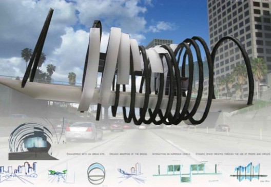
Through the use of simple forms, rings and rectilinear volumes, an organic structure is brought to the urban site. By changing the diameter and the spacing between the structural rings the bridge becomes wrapped by an undulating tube, enhancing the organic nature of the form and bringing a dynamic quality to the building. This provides a large variety of experiences for both motorists and pedestrians engaging the building. Translucent rectilinear volumes suspended from the rings fulfill the programmatic requirements. Following the undulations of the structure, the skin sits between the rings and provides access to the rectilinear volumes. At night these volumes glow adding an addition layer to the dynamic character of the building.


The design embraces both the topside and the bottom side of Wilshire Blvd. bridge, through the use of pedestrian paths. The building fulfilling the programmatic functions hangs below the bridge and is connected to it by a pathway that allows the pedestrian to explore the previously unused space. Ascending above the Wilshire Blvd.

bridge is another pedestrian path providing an elevated experience in which to view the city. The mast like structures of the elevated path serve as a billboard for the motorist and pedestrians alike both on and below the Wilshire Blvd. bridge.


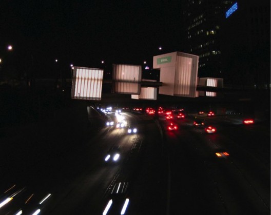
A series of cubic volumes are latched onto each side of the bridge, engaging both motorists and pedestrians on the bridge, and motorist below the bridge. Each cube has a unique relationship to the bridge established by its planer orientation and the depth to which it latches onto the bridge. The interstitial spaces created between the cubes become as significant as the spaces within the cubes, framing views and creating places for the pedestrians to pause. Translucent facades are located on the sides of the cubes facing the direction of travel along the 110 Freeway, again framing views and providing an awareness of the city for the people inside the buildings. Both the opaque and translucent facades offer the opportunity for the buildings to act as billboards, further reinforcing awareness.


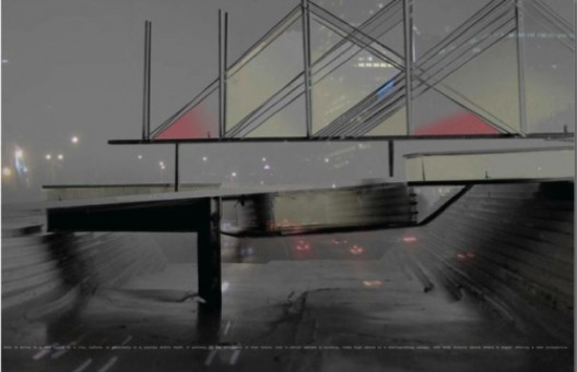
Oscillating from one edge of Wilshire Blvd. bridge, under and to the other edge, the structural system repeats itself along the direction of the bridge, creating ribbon-line bands running parallel to the 110 Freeway below. The bands contain means of entry, circulation, and program on the interior while serving as billboard on the outside for the motorists along the freeway. In the evening the building glows from between the structure further expressing the space on and below Wilshire Blvd. bridge.


Choosing to maintain the identity of the bridge, the design embraces the traditional bridge icon by utilizing an arch structure. The programmatic space exists between the two arches, and the bridge is unified with the building through the use of a translucent skin. During the day, the bridge showcases the art gallery and displays its roof garden, creating a unique haven within a dense city. At night, the translucent building facade glows alive while the cylinder of light conveys traffic conditions to motorists.

 
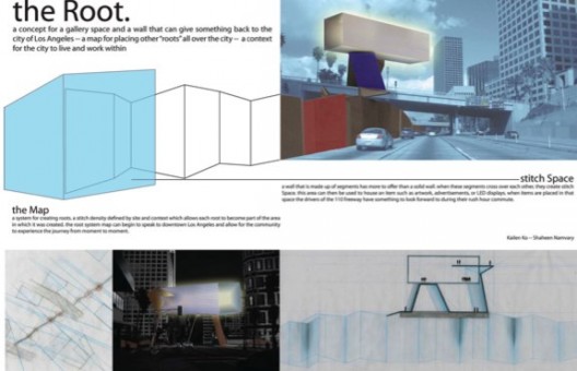
The 110 Freeway defines a major boundary of the city of Los Angeles as well as a link between the traveler and the inhabitant. By creating a wall to interact with drivers beneath the overpass and the traffic on Wilshire Blvd., there is a dialogue between the two axes of movement. The undulating wall caters to the pace of the freeway. It gives the drivers of the 110 Freeway a boundary between north and south movement, while dynamically engaging their daily commutes. Stitch spaces create opportunities within the wall for installations and further engagements. The building emerges from the freeway straddling the overpass, folding within itself to embrace the gallery floating above the bridge. 


The bridge is celebrated as an element which serves to connect downtown Los Angeles with the neighboring districts. By wrapping the bridge with a series of translucent buildings a rhythmic relationship of static and dynamic layers is created. The buildings as a larger complex are uniquely experienced from each direction of vehicular movement. The layers are further articulated through the structure of each building, fulfilling the programmatic requirements, but also allowing the buildings to become places of personal retreat and awareness. 

From: http://la.curbed.com/archives/2008/05/last_month_a_de.php#wilshire-bridge-6

Tuesday 1 March 2011

Death By Freeway


From: http://www.architizer.com/en_us/projects/view/death-by-freeway/6066/ 

This project seeks to reinvest the formally charged space of the highway with a program of highly charged spiritual space. A network of cables is tensioned within the freeway overpasses, suspending a field of inverted trees whose canopies become an actively growing floor plane. Ashes are laid into the ground atop the trees' roots which are trained to grow about a steel trellis whose exposed members provide both space and shelter for the act of remembrance.

Thursday 24 February 2011

Mobility: A room with a view (Rotterdam Biennale 2003)

Official Website
http://www.iabr.nl/2003/

1st International Architecture Biennale Rotterdam

Rotterdam will hosted the first International Architecture Biennale Rotterdam from
7 May - 7 July, 2003. The first Architecture Biennale focused entirely on the theme of mobility, examining the issue of modern-day mobility and the consequences for architecture and urban development. Architects, civil engineers, urban planners, traffic experts, landscape architects, students, filmmakers and photographers from around the world spent two months presenting plans and exchanging ideas in the form of exhibitions, lectures, publications, debates, films and excursions. The curator was Francine Houben, partner in the Mecanoo architecture firm and professor at Delft University of Technology.

Wednesday 23 February 2011

Urban movement scripts


Scripts in the journey of metrobus and taxi, showed urban spaces encountered. I transfered this sequence of urban images into series of spaces in smaller scales, which might be integrated with local life in function, like teahouse. In this method, I hoped spaces under the highway which were underutilization could attract more citizens to visit and use.

Scripts of Galata bridge


sketches of sceneries in Galata bridge in every six seconds, comparing sceneries on tram and bus.

Thursday 10 February 2011

gaps of transportation


Transportation system connects different parts of the city but also disconnected some parts. One of the most apparent examples are spaces under highways, which are low efficient. Another example is the main car road along the Golden Horn, which decreases the link between two sides of the road. On one side, there are lively gattos, on the other side, there are grassland along the waterfront.

illusions


layed images of istanbul on vehicles.

Friday 4 February 2011

Experimenting speeds


Modern technologies afford us with a wide range of choices to exprience the city on different vehicles. They are not only considered as some machine which carry passengers, but also means of observing the city and urban life. We manage to travel in different layers of the city, reaching somewhere far away that we haven't expected. Accelerating speeds even changed our sensitive experiences of urban spaces. By controling speeds of our trip, we can even change our feelings of the city. This short vedio is a basic experiments of Istanbul at different speeds. I am trying to explore the idea of speed and space by changing the playing speed of the original vedio. The moving vehicle is also like a object where I am hiding and observing local life without being noticed.

Friday 28 January 2011

Journey from west to east


The journey from west to east. We took a tram to a transition station of metrobus and then travelled by metrobus across Golden Horn and Bosphorus, arriving at Kadikoy. Then we went back to Sisli and travel to Taksim by metro, where the old tram started. At the same time, another ferry trip started in Kabatas.

Thursday 27 January 2011

Passing Galata bridge at different speeds


This vedio shows experiences on Galata Bridge at different speeds and diffrent time. At the end of the vedio, vedios on buses, trams and taxis are compared together. Better quality please click the vedio and connect to Youtube.

Istanbul on vehicles

My exploration in Istanbul began with different kinds of vehicles. There a variety choice of vehicles in Istanbul, trams, buses, metros, ferries, metrobuses, suburban trains, taxis and old tram. They run in different layers of the city but connect and overlap, which offer with us another dimension of experiencing the city. The city would be different once I boarded on a different vehicle. I may come across surprises when moving in the city.

Adventure routes

tram: between Kabatas and Zeytinbumu


Old gram: between Taksim and Tunel


metro: between Sisli and Taksim


suburban train: between Sureyya Plaji and Haydarpasa, between Sirkeci and Yenikapi


bus:round trip in Eminonu, between Emirgan and Bosphorus Bridge


metrobus:between Cevizlibag AOY and Sogutlucesme


ferry: Bosphorus-between Kabatas and Emirgan, between Eminonu and Kadikoy, between Haydarpasa and Karakoy. Golden Horn-between Eminonu and Eyup


taxi: between Eminonu and Halic Bridge, between Bosphorus bridge and Cemberlitas